The Woolley Moor Trail |
The present village of Woolley Moor, is dominated and has been influenced by the construction of Ogston Reservoir in 1958. It is situated close to the Derbyshire Peak District and just a few miles from Chesterfield, Alfreton, Clay Cross and Matlock. It is a village that is immediately attractive to visitors and we hope you will explore it with us, enjoying not only its present attractions but also its fascinating history.
Our trail is marked with posts bearing the Stretton Handley School logo "The Grebe", which also mark points of particular interest. We hope you will be encouraged to research to extend your knowledge and create activities from the information we have given you. Schools can use our trail to cover Attainment Targets in many curriculum areas at different levels. Most of the information we give you is from the local residents upon whose memories we have drawn.
Some of our trail is along narrow lanes which have sharp bends and no pavements. Remember to face the on coming traffic and to keep children and animals under control. You are also advised to dress sensibly for all weathers and wear strong footwear.The sections of the trail that lead from the A61 across Handley Fields Farm and Well Lane could prove difficult for elderly or infirm walkers or people with push chairs. They are also very muddy in wet weather. In both cases you can enjoy the trail by using the road.
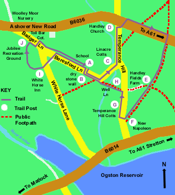
The circular trail begins and ends in front of the school situated in Beresford Lane in the heart of the village. You can navigate the Trail online by clicking an area of interest on the map below or take a tour of the whole trail by clicking on the grebe logo at the bottom of each page. You can also download or listen to our brand new audio trail (right-click to download), created through the Hidden Gems project. It draws upon the original trail written by Mrs H T Badhams as well as including additional information and interviews with members of the community. There are laminated maps available in a box outside school. Please return these after your walk.
In 1986, the BBC launched a project called Domesday which aimed to providing a snapshot of everyday life across the UK for future generations. The school and the surrounding area were included in the project. Visit the Domesday website to find out what Woolley Moor was like in 1986. There's even an account about school dinners!
The village has existed since medieval times but the present village of Woolley Moor is very different from the one that existed before the construction of Ogston Reservoir in 1958. At present it takes in the hamlets of Handley, Woolley Moor and Woolley, consisting of about 140 dwellings in total. Most of the original Woolley was demolished to make the reservoir. Woolley Moor used to be towards the bottom of Temperance Hill; and the present village was known as Badger Lane extending from the Toll House to the White Horse Inn.
The small community of Badger Lane stayed virtually the same until 1945-50. The road towards Stretton had been made wider in the late 30's, renamed Ashover New Road and properties built along it. When Ogston Reservoir was built people from the village of Woolley were rehoused in council property on Badger Lane and in consequence Badger Lane and Woolley with Woolley Moor became one community known as Woolley Moor.
